

![]() There are nine MODIS Standard Atmosphere products produced from MODIS instruments on two satellite platforms: the Terra platform and the Aqua platform. Six of these are Level-2 or L2 (Orbital Swath) products. Three of these are Level-3 or L3 (Global Gridded) products produced at Daily, Eight Day, and Monthly temporal scales. Note that the L3 product includes data from all of the L2 products. Each product is assigned an Earth Science Data Type name (specified below), which is used as the prefix in the HDF4 filename, as well as for cataloging and archiving the datasets. The L2 and L3 MODIS Standard Atmosphere products are:
There are nine MODIS Standard Atmosphere products produced from MODIS instruments on two satellite platforms: the Terra platform and the Aqua platform. Six of these are Level-2 or L2 (Orbital Swath) products. Three of these are Level-3 or L3 (Global Gridded) products produced at Daily, Eight Day, and Monthly temporal scales. Note that the L3 product includes data from all of the L2 products. Each product is assigned an Earth Science Data Type name (specified below), which is used as the prefix in the HDF4 filename, as well as for cataloging and archiving the datasets. The L2 and L3 MODIS Standard Atmosphere products are:
Level-2
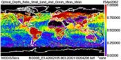
L2 Aerosol (MOD04_L2 & MYD04_L2)
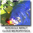
The MODIS Aerosol Product monitors the global (except for over ice and snow) ambient aerosol optical thickness (AOT; also known as aerosol optical depth, AOD) for non-cloudy conditions during daytime. The primary Level 2 data (retrieved along the orbit) are produced at the spatial resolution of a 10x10 km (at nadir). Due to large differences in surface optical properties, global coverage requires multiple algorithms to retrieve aerosol properties over ocean, over dark vegetated land, and over bright land, respectively. There are two flavors of Aerosol retrieval algorithms: Dark Target and Deep Blue. There is also a merged or combined Aerosol Scientific Data Set (SDS) with aerosol retrievals from both of these algorithms in the Aerosol HDF Product File. The ESDT names are MOD04_L2 (Terra) and MYD04_L2 (Aqua). In addition to the standard 10 km product, AOT is derived over ocean and dark vegetated surfaces at 3 km (nominal, at nadir) resolution, and contained in MOD04_3K and MYD04_3K product files for Terra and Aqua.

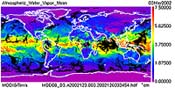
L2 Water Vapor (MOD05_L2 & MYD05_L2)
The MODIS Water Vapor product consists of column water-vapor amounts. During the daytime, a near-infrared algorithm is applied over clear land areas of the globe and above clouds over both land and ocean. Over clear ocean areas, water-vapor estimates are provided over the extended glint area. An infrared algorithm for deriving atmospheric profiles is also applied both day and night for Level 2. The ESDT names are MOD05_L2 (Terra) and MYD05_L2 (Aqua).
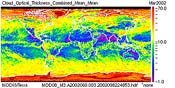
L2 Cloud Properties (MOD06_L2 & MYD06_L2)
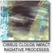
The Cloud Product monitors the physical and radiative properties of clouds including cloud particle phase (ice vs. water, clouds vs. snow), effective cloud particle radius, cloud optical thickness, cloud shadow effects, cloud top temperature, cloud top height, effective emissivity, cloud phase (ice vs. water, opaque vs. non-opaque), and cloud fraction under both daytime and nighttime conditions. The ESDT names are MOD06_L2 (Terra) and MYD06_L2 (Aqua).
L2 Atmospheric Profile (MOD07_L2 & MYD07_L2)
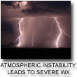
The MODIS Atmospheric Profile product consists of several parameters: they are total-ozone burden, atmospheric stability, temperature and moisture profiles, and atmospheric water vapor. All of these parameters are produced day and night for Level 2 at 5x5 1-km pixel resolution when at least 9 FOVs are cloud free. The ESDT names are MOD07_L2 (Terra) and MYD07_L2 (Aqua).
L2 Cloud Mask (MOD35_L2 & MYD35_L2)
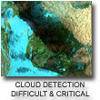
The Cloud Mask Product indicates whether a given instrument field of view (FOV) of the Earth's surface is unobstructed by clouds or affected by cloud shadows. The cloud mask also provides additional information about the FOV including the presence of: cirrus clouds, ice/snow, and sunglint contamination. Finally flags denoting day/night and land/water are included. The ESDT names are MOD35_L2 (Terra) and MYD35_L2 (Aqua).

L2 Joint Atmosphere (MODATML2 & MYDATML2)
The post-launch Joint Atmosphere Product contains a spectrum of key parameters gleaned from the complete set of standard at-launch Level 2 products: Aerosol, Water Vapor, Cloud, Profile, and Cloud Mask. The Joint Atmosphere product was designed to be small enough to minimize data transfer and storage requirements, yet robust enough to be useful to a significant number of MODIS data users. Scientific data sets (SDS's) contained within the Joint Atmosphere product cover a full set of high-interest parameters produced by the MODIS Atmosphere group, and are stored at 5-km and 10-km (at nadir) spatial resolutions. The ESDT names are MODATML2 (Terra) and MYDATML2 (Aqua).
Level-3
L3 Daily (MOD08_D3 & MYD08_D3)
The Daily Global Joint Product contains roughly 600 statistical datasets derived from Level-2 MODIS Atmosphere parameters that are summarized over a 24-hour (00 to 00 GMT) period. The ESDT names are MOD08_D3 (Terra) and MYD08_D3 (Aqua).
L3 Eight Day (MOD08_E3 & MYD08_E3)
The Eight-Day Global Joint Product contains roughly 800 statistical datasets derived from Level-2 MODIS Atmosphere parameters that are summarized over an 8-day period. The ESDT names areMOD08_E3 (Terra) and MYD08_E3 (Aqua).
L3 Monthly (MOD08_M3 & MYD08_M3)
The Monthly Global Joint Product contains roughly 800 statistical datasets derived from Level-2 MODIS Atmosphere parameters that are summarized over a monthly period. It should be noted that the content of this product is identical to the Eight-Day Global Joint Product, except for the time period covered. The ESDT names are MOD08_M3 (Terra) and MYD08_M3 (Aqua).